To start off, we'd like to wish all our readers a Happy New Year and may 2019 hold the best in store for you. Likewise, to start the year off on a good note, we'll be looking soil investigation works at the Cross Island Line's (CRL) eastern phase's western terminus - Bright Hill station on the Thomson-East Coast Line (TEL).
Bright Hill station is located in the Sin Ming neighbourhood and was the only station along the Thomson Line section of the TEL to have its name changed during the station naming exercise. Initial plans for the station saw the construction of a four platform, two level station which would allow for the cross platform transfer between the TEL and a future line, which we now know to be the CRL.
 |
Station concept render of the proposed station.
Source: GreenhiLi |
 |
Cross section view of a station concept render for T7 station of the then Thomson Line.
Source: GreenhiLi |
It is believed that the CRL tunnels may have continued northwards to run under Ang Mo Kio Avenue 3 together with the TEL tunnels, eventually swinging eastwards to continue to Ang Mo Kio station on the North South Line. Eventually, this concept was scrapped in favour of building the stations for the two lines as separate stations. A more recent fly-through render video by
Momo Graphics shows that the TEL station is being constructed as a two platform, single level station.
Below are some screenshots from the above flythrough render that show the platform area. It is worth noting that the layout in the station differs from that of the stacked station with cross platform transfer arrangements.
 |
| Screenshot from 3D flythrough render of Bright Hill station showing single level island platform. |
We can also confirm that the station is being built per the above render through some images we managed to find online. It is noted that this particular entry had only one escalator accompanied by a stairway while the opposite end has two escalators.
 |
02.05.2018 - An interior view of Bright Hill station construction at concourse level looking to the platform.
Source: MortarMaster |
In the 3D render flythrough, it can be seen that there is an additional fareline that opens up to a bank of four escalators and an additional elevator. Such arrangements are typically used when transfers to another line are required, as in the case of Bishan and Serangoon stations on the Circle Line and Woodlands on the upcoming TEL. This is highly indicative of the connection to the CRL at Bright Hill being placed at the northern end of the station and potential future works will be necessary to connect it to the TEL station via a transfer link.
 |
| Screenshot of above 3D flythrough render of Bright Hill TEL station concourse showing additional fareline & elevator. |
 |
| Screenshot of 3D flythrough render of Bright Hill TEL station platform level showing bank of four escalators. |
In line with the expected location of the CRL station under Sin Ming Avenue, soil investigation works have been noted along the road and cross over onto Sin Ming Walk, stretching up to Upper Thomson Road. Below are some of the boreholes spotted.
 |
| 05.09.2018 - Soil Investigation borehole |
 |
05.09.2018 - Vague details of above borehole indicating that the client is
Land Transport Authority. |
 |
05.09.2018 - Further soil investigation works in progress in the green strip opposite Ang Mo
Kio - Bishan Park, next to the site of Eunoia Junior College. |
 |
| 05.09.2018 - Borehole at junction of Bright Hill and Sin Ming Avenue. |
 |
| 05.09.2018 - Detail of above borehole. |
 |
| 05.09.2018 - Borehole in between blocks 408 and 407. |
 |
| 05.09.2018 - Details of above borehole. |
 |
| 05.09.2018 - Borehole along Sin Ming Walk, outside former Bishan Park Secondary School. |
 |
| 05.09.2018 - Details of above borehole. |
 |
| 05.09.2018 - Borehole located outside Bishan Park condominium. |
 |
| 05.09.2018 - Borehole located outside Pierce Secondary School, along Sin Ming Walk. |
 |
| 05.09.2018 - Borehole near The Gardens At Bishan condominium. |
 |
05.09.2018 - Borehole next to bus stop outside Pierce Secondary School
along Upper Thomson Road. |
 |
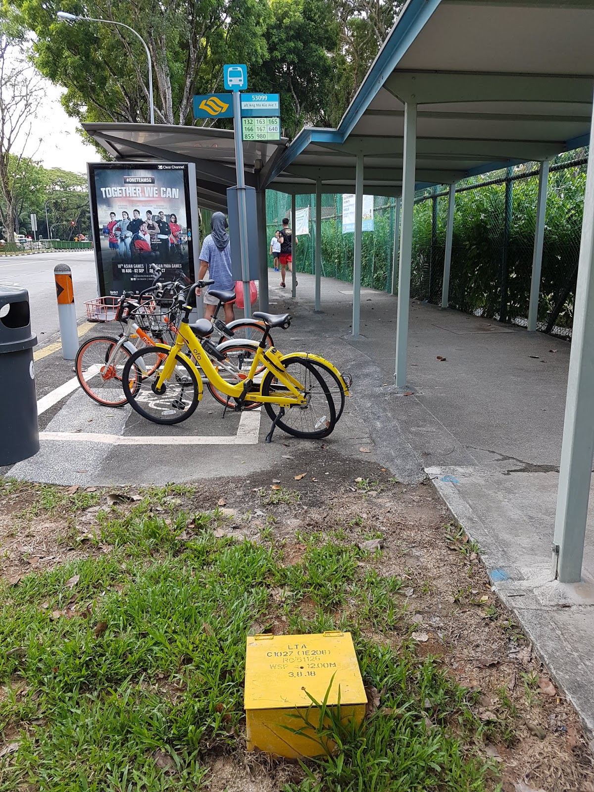
| 05.09.2018 - Second borehole at bus stop outside Pierce Secondary School. |
 |
| 05.09.2018 - Borehole along Upper Thomson Road northbound carriageway. |
 |
| 05.09.2018 - Details of above borehole. |
Felixius, a contributor, was kind enough to share with us a few pictures of soil investigation works happening along Upper Thomson Road. These have been noted to be for the last 2 boreholes pictured above. We would like to thank Felixius for his contributions and welcome any information on soil investigation works sighted - do drop us an email which can be found on the contact us page if you have any pictures or information you'd like to contribute.
 |
Soil investigation work along Upper Thomson Road, outside Pierce Secondary School.
Contributor - Felixius |
 |
Soil investigation work along Upper Thomson Road, opposite Pierce Secondary School.
Contributor - Felixius |
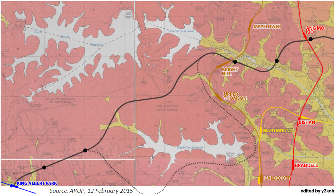
Based on the locations of the boreholes along Upper Thomson Road, we are unable to determine if the line will use option 1 of going under the Central Catchment Nature Reserve (CCNR) or option 2 of skirting around the reserve to connect to the western leg of the line, consistent with the Land Transport Authority's (LTA) stance as of 2018 that a decision has yet to be reached.
 |
Excerpt from the Environmental Impact Analysis by LTA, edited to show the alignment options for the CCNR crossing and edited by y2koh.
The black dots are indicative of potential station sites and are not confirmed stations. |


No comments:
Post a Comment